
The Prioritization of Survey Through Open-Source Research in Ukraine
CISR Journal
This article is brought to you by the Center for International Stabilization and Recovery (CISR) from issue 28.2 of The Journal of Conventional Weapons Destruction available on the JMU Scholarly Commons and Issuu.com.
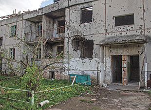
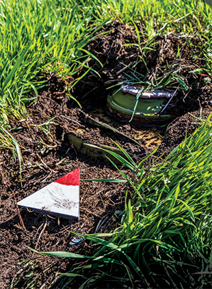
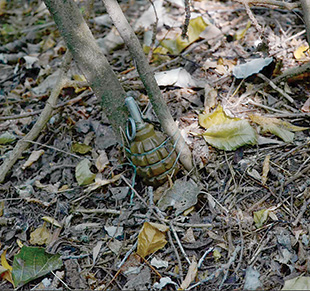
With the increasing quantity of available and relevant open-source information online, the mine action sector is well poised to take advantage of its accessibility for conducting research, analysis, and investigations. In current conflicts, such as in Ukraine and Yemen, online sources are a rich repository of information which can be leveraged for survey and clearance operations. Humanitarian mine clearance actors can harness this vast quantity of information to map conflicts and their effects, including the location of landmines and other explosive remnants of war (ERW). In turn, this can be used to help prioritize survey efforts, especially in contexts where resources are limited and the need is great. The HALO Trust (HALO) has successfully applied this methodology in Ukraine and is expanding it to other locations as well.
Introduction
Open-source research (OSR), defined as “the process of collecting and analyzing legally gathered information from publicly available sources,”1 is a relatively new tool within the mine action sector but has a long-standing history of use by law enforcement and national security organizations.2 Within mine action, OSR is a growth area with the promising potential to improve non-technical survey (NTS) directly and land release in general.
The HALO Trust.
Examples of OSR include the following: monitoring social media to map explosive ordnance (EO) contamination in a conflict zone, archival research to understand minelaying patterns in past conflicts, and the analysis of current and/or historical satellite imagery to map craters, roads, and trenches. All of these are used to assist with the process of NTS, traditionally acting as part of the desk-based assessment prior to the deployment of NTS teams which help inform further survey priorities.3 Prior to the deployment of teams on the ground, however, information gathered online or in archives can be used to prioritize the survey process.
HALO has leveraged open-source information online since the full-scale invasion of Ukraine in February 2022 to help prioritize survey areas. This has improved the efficiency and effectiveness of HALO to deploy survey teams and conduct rapid assessment of settlements that leads to the identification of suspected hazardous areas (SHA) and confirmed hazardous areas (CHA).
Open-Source Research in Mine Action and The HALO Trust
At HALO, OSR has become an integral part of the planning process for both new country operations and the expansion of efforts in existing locations. In Ukraine, HALO has been continuously conducting OSR since the start of the conflict in 2014, monitoring social media posts and intelligence assessments to ensure the safety and security of our staff, as well as to have an in-depth understanding of the conflict and the resultant EO contamination across the nation.
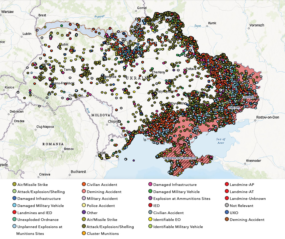
HALO’s research team has created a map by collating, categorizing, geolocating, and analyzing over 100,000 data, which point to or directly identify locations that are likely contaminated by EO.4 Figure 1 includes movement of the frontlines, and HALO’s safety buffer from the front-line areas. This data has been used for various strategic decisions, including security assessments and survey prioritization.
Survey Prioritization Through Open-Source Research
Scope and unit of analysis. The scope of HALO’s prioritization efforts aligns geographically with its current area of operations (AO). At the regional level, HALO holds permission to operate in specific areas, including parts of Kyiv, Chernihiv, Sumy, Kharkiv, Mykolaiv, Donetsk, and Kherson Oblasts, as permitted by the Ukrainian authorities. A narrower and more local focus occurs at the district and territorial community (hromada). Characterized as larger than a settlement, a hromada encompasses numerous settlements. It is by focusing on this unit that HALO distinguishes itself geographically from other mine action operators’ AO. This approach has been beneficial due to the size of Ukraine and the nature of the conflict, where the majority of minelaying has occurred in agricultural areas or in the vicinity of smaller settlements. By prioritizing at the hromada level, HALO ensures that this unique aspect of the conflict is taken into consideration throughout the survey process.
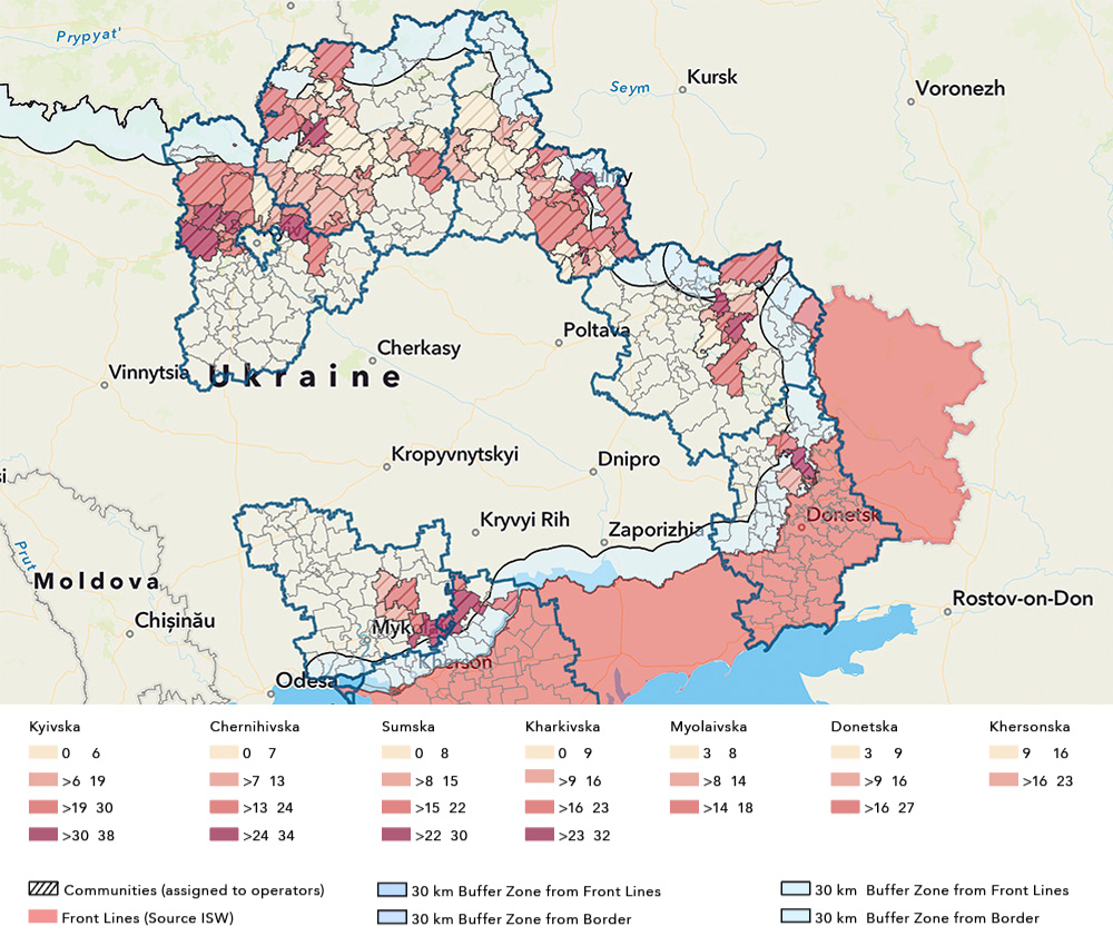
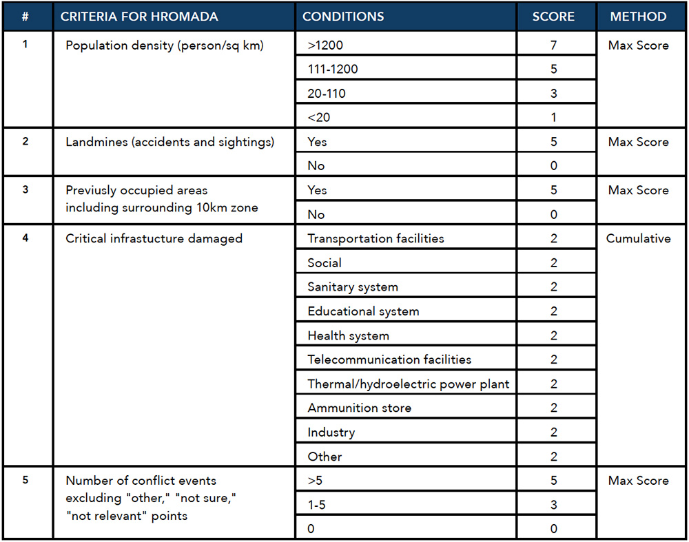
At this level, HALO has established prioritization criteria for hromadas falling within HALO’s AO. The prioritization is visually represented through a color-coding system, where darker colors signify higher priority areas (Figure 2). This approach ensures a systematic and strategic deployment of resources in areas requiring more attention and intervention over others with a lower priority.
Methodology. OSR reports within HALO’s AO are systematically gathered, starting with various aspects related to landmines, encompassing both reported accidents and reported sightings. The analysis extends to areas under occupation since February 2022, which includes liberated areas and a surrounding 10-kilometer zone. This comprehensive approach allows insight into the evolving dynamics and mitigates any potential issues stemming from any data incompleteness.
Infrastructure damage is meticulously cataloged, with each category assigned a cumulative score based on the impact to local communities and the importance of the infrastructure. The classifications include transportation facilities such as roads, railways, bridges, and airports; social infrastructure facilities such as theaters, stadiums, libraries, government offices, banks, and other financial institutions; sanitary systems such as drinking water, waste management, and dams; telecommunication facilities such as television, mobile, and internet; and other infrastructure as seen in Table 1.
The analysis further encompasses the quantitative assessment of conflict events reported through ORS, excluding points categorized as "other," "not sure," and "not relevant." This enables HALO to quantify and understand the magnitude of events directly related to the conflict.
An additional parameter is the population density for every hromada within HALO's AO. This information, publicly available from the Ukrainian authorities, contributes to a more nuanced understanding of the demographic landscape in the areas under consideration. It also highlights areas where human activity is more likely to overlap with EO contamination, potentially resulting in an increased likelihood of accidents.
Considerations. The outlined considerations form an essential framework designed to provide strategic guidance to senior management in determining the priority areas for survey deployment. This pre-survey assessment aims to streamline the allocation of limited resources effectively before survey teams physically visit identified areas. Several key points define the structure of this prioritization process.
Firstly, the prioritization criteria extend to each specific region in HALO’s AO. This regional focus allows for a nuanced approach, recognizing the unique characteristics and challenges in each area—such as highlighting differences in tactics used during the conflict.5 The analysis is limited to hromadas within HALO's AO, with regular updates incorporated over time to ensure accuracy and relevance. By confining the assessment to HALO AO hromadas, the prioritization efforts are adjusted to each specific operational context.
A priority color scale is employed to distinguish the urgency and significance of each area. This scale classifies priority into four categories: low, medium, high, and very high (specific scores depending on region). This systematic grading system facilitates a clear and intuitive understanding of the relative importance of surveyed areas.
The system aims to target and plan interventions in higher-priority areas, thereby optimizing resource allocation. However, in specific instances, such as in Kharkiv Oblast, survey teams extend their assessments to include the closest villages in the surrounding areas, demonstrating the ability for a flexible and context-specific approach. In other areas, such as Mykolaiv Oblast, the unique operational context necessitates a more constricted strategy due to security and access considerations.
Outcomes. The prioritization matrix assigns each hromada a specific score accompanied by a corresponding color scale indicative of its priority score. The web map interface facilitates access to detailed information related to each criterion within the matrix by simply clicking on the respective hromada, thereby providing a comprehensive overview of its prioritization factors. This is accessible both on laptops and mobile devices.
Drawing from cumulative results thus far, a significant trend emerges. Within one-third of the hromadas located within HALO’s AO, evidence of landmines is apparent. Notably, 90 percent of these hromadas were occupied, approximately half have incurred infrastructural damage, and more than half have been affected by some form of conflict event. These findings underscore the multifaceted impact of conflict and provide a foundation for prioritizing ongoing and future survey and clearance efforts.
Evaluation Through Rapid Assessment
Evaluation. The accuracy of HALO’s survey prioritization based on open-source data and the priority matrix has been confirmed by the rapid assessment of communities by HALO’s NTS teams. Rapid assessment does not fall under the definition of NTS in the International Mine Action Standards but is used by HALO as a precursor to NTS to assist a program in prioritizing areas most affected by EO for deployment of NTS teams. During the process of rapid assessment, NTS teams will visit all settlements in a defined area and collect information about the presence of direct or indirect evidence of EO without defining a polygon. This is completed through interviews with a small number of informants to determine if there is any evidence of explosive contamination in the village or not. This is not a comprehensive approach but provides a rapid picture of the contamination in an area, as well as a starting point for future NTS activity. When all localities are visited by teams, those which show direct and indirect evidence of contamination will then be prioritized on the NTS work plan, during which CHA and SHA polygons are created.
HALO has conducted rapid assessment of communities in Ukraine since 2016. After 24 February 2022, this has been used to both confirm the prioritization based on open-source data and to further help prioritize NTS across Ukraine given the scale of the conflict and the size of the country.
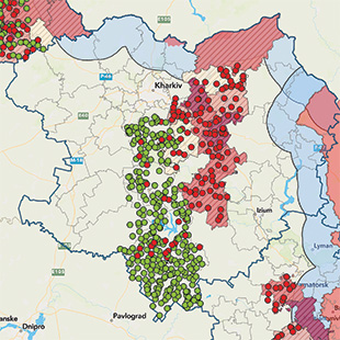
The color-coded map excerpt (Figure 3) shows the prioritization of the communities (the highlighted areas) and the results of HALO’s rapid assessments. The location of rapid assessments, which confirm the presence of EO (in red) match, on average, HALO’s high priority communities. The green points, which show no presence of EO, match HALO’s low priority communities.
Possible issues. Some of the major potential problems when conducting survey prioritization based on open-source data are the accuracy and availability of the data, the construction of the matrix, and context-specific issues. While some of these issues are surmountable, others may have insoluble negative effects, which must be mitigated during the strategic decision-making process.
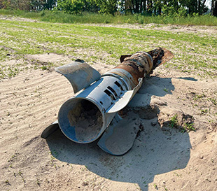
Data availability and accuracy are vital to the correct prioritization of survey areas. The Russian invasion of Ukraine has been described as “the world’s first TikTok war,” resulting in effectively endless imagery and footage of the conflict.6 While the availability of data is not an issue, the largest problem stems from capturing and analyzing the information given limited resources. Thus, certain types of data need to be prioritized. HALO’s research team in Ukraine focuses on any footage that highlights the presence of landmines and ERW, such as reports of civilian accidents, footage of tanks being hit by landmines, or videos of cluster munition strikes. However, even with the added prioritization of this data, lapses in the most pertinent data are still possible due to the size of both the conflict and Ukraine.
Another potential issue can occur during the construction of the prioritization matrix. If, for example, the population data is inaccurate or outdated, this may create a wrong output. Similarly, if the scoring steps for the same criteria are not selected properly, taking regional deviations into consideration, such as the presence of large cities in otherwise sparsely populated areas, this might also contribute to a less effective prioritization.
Lastly, considering the characteristics of the conflict is vital to an effective prioritization. While the Russian invasion of Ukraine has resulted in the largest war in Europe since World War II, it remains a conventional war and highly attritional in nature. While trenches, artillery, tanks, and landmines are ubiquitous across the frontlines in Ukraine, these elements are less likely to be present in other war zones, where conflicts might materialize more as insurgencies or occur mostly in urban areas. In these cases, improvised explosive devices might be more common than landmines and determining occupied areas and frontlines may be more challenging or complex. If survey prioritization is conducted via the previously mentioned methods, a unique matrix must be created for each conflict accounting for demographic, regional, and geographic differences.
Looking Forward
HALO is beginning to augment existing desk-based analysis and previous processes of the prioritization of survey through initial OSR scoping and thorough analysis of conflict history in other regions, such as Southeast Asia and across the Middle East. The lessons learned from Ukraine described in this article have been instrumental in streamlining the process dependent on the country and conflict context. As scraping technologies, such as machine learning algorithms and artificial intelligence improve, OSR’s significance within mine action will only continue to expand.
See endnotes below.
 Anda Riza is an Operations Officer at The HALO Trust Ukraine (HALO), supporting clearance operations and overseeing non-technical survey. Riza completed her Field Officer training in Sri Lanka, prior to which she served as a Non-Technical Survey Coordinator for HALO Ukraine. She is currently working on her master's degree in international management from the International Business College Mitrovica in Kosovo. Riza has worked with HALO for six years.
 Andro Mathewson is a Global Research Officer at The HALO Trust (HALO), leading HALO’s open-source research project mapping the Russian invasion of Ukraine. He received his master's degree in international relations from the University of Edinburgh and bachelor of arts in politics, philosophy, and economics from the University of Pennsylvania, and is currently working on his PhD in war studies at King's College London.